Recorders: our config!

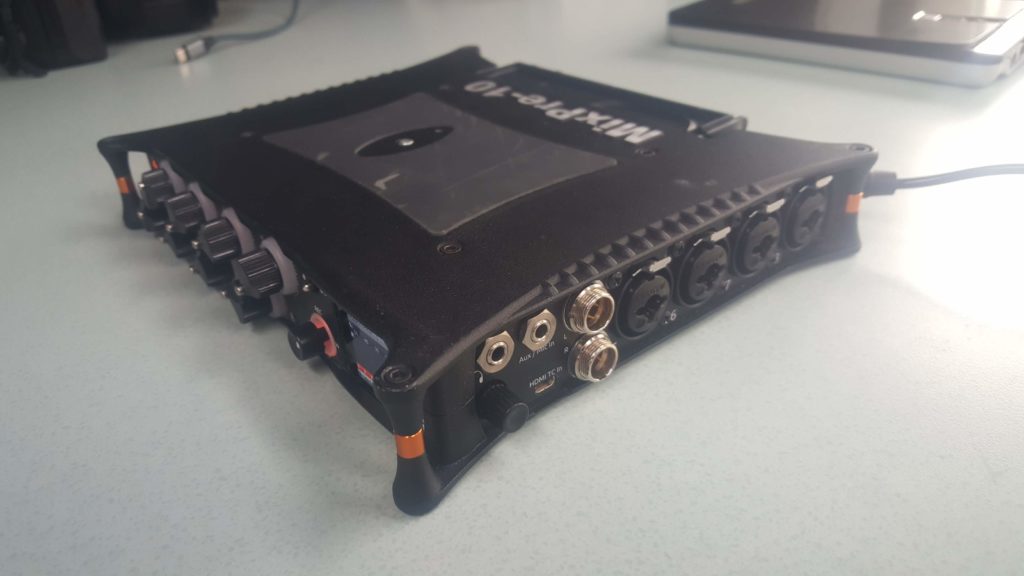
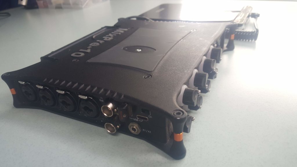
With microphones, the recorder is the main part of a sound recording setup. We were looking for a recorder with at least 4 XLR inputs with Phantom power, which is compact and weatherproof; but also which have a very good quality of preamps. Due to its quality, reputation and quality/price ratio, we opted for a Sound Devices MixPre10T:

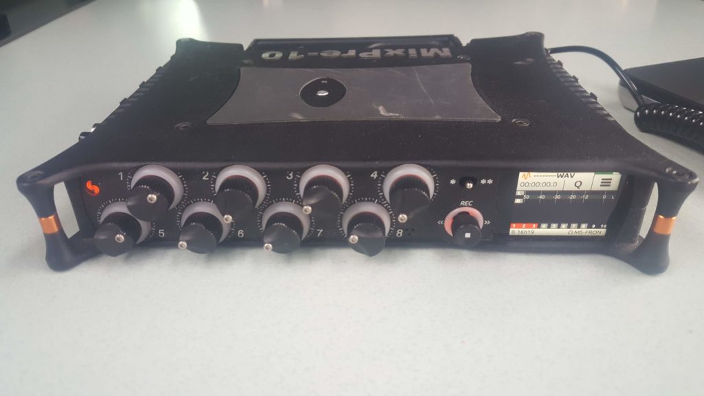
finally, we opted for this model which has x8 combo-XLR inputs, with in mind the idea to record several configurations of microphones at the same time during a single take:

-DMS (3 mics)

-AMBEO (4 mics)

-Parabola, TELINGA (1 mics)


This recorder offers several advantages:

-8 input combo XLR, with phantom power

-Low cut filter + limiter per track

-16/24 bit to 192 kHz converters

-Possibility of efficient routing / monitoring (eg possibility to monitor in MS mode, while recording the different inputs separately)

-Possibility to couple the inputs between them (a single gain button, several input control, very convenient for taking stereo sounds, DMS, Ambisonic, etc. ..)

-Hirose connector power supply (10-18 V) (allowing the use of external batteries)

-Simultaneous recording on SD card + USB key (allowing real time backup)

-Possibility to save presets config , for different mic setup (MS, DMS, Quad, ORTF, Ambisonic, etc …)

-Ability to control the recorder remotely via mobil phone (Start / End recording, level control)

-It can run as a sound card, when it is connected in USB to computer (very useful in nomad mode)


that is essentially for us, it obviously offers other functions for other uses (such as time code for example)

I would say that for a field recording use, it is an excellent quality/price ratio.

We have two other recorders in backup:

-x1 Fostex FR2LE (x2 XLR input)

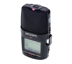
-Zoom H2N (no XLR input, 4 integrated capsules) allowing quad (4.0) recording, but also ambisonic, B format (Ambix)


The glaciers of Alaska

After our immersion in the the northern Alaska via the Dalton highway, we naturally turned to the Pacific coast and especially the Kenai peninsula, known for its famous glaciers.

Alaska has more than 600 glaciers, mostly inaccessible. But since nothing resists to human, this precious and fragile treasure is fuels polluted and is becoming noisy with it luxuary tourism, for anyone in a hurry: cruise, boat, helicopter tour, everything is planned to see a max in a minimum time. Our luxury is to have time and hiking shoes to reach accessible glaciers at a modest price and some effort.

GLACIER PORTAGE
A short hike from Whittier makes it easy to see the front, which remains very distant, as it is declining from year to year.

An extra walk along the lake, an icy knee-high river crossing and a bit of climbing offered us a tense head-to-head with the high glacier.
Unstructured, broken, compressed forms build cathedrals with translucent and vibrant walls

Below, it’s a whole network of caverns, invisible, but audible: it creaks, drips, breaks, and falls.

We advance towards the front of the glacier, overlooking it. The blocks are detached from time to time and drift along the lake.
We spend the day here, alone, listening and recording this living glacier.

EXIT GLACIER
It is accessible from Seward, a small fishing town, for which we had a crush (blue sky, heat and northern lights as a bonus)

This glacier is also declining, but continuously, since 2006, winter and summer. The approach walk to observe the front is more and more longer and retraces 195 years of decline. The trail has experienced several extensions, but there will be no other, the glacial tongue being surrounded by a terrain considered too abrupt now. We opted for the harding field trail, an all-round hike of 12 km, to admire the ice field on the heights of the Exit glacier. After crossing a forest of dense poplars, grasslands with marmots, we finaly arrive in front of the immensity of the ice field. It can be said that this was a highlight of the trip, which is self-explanatory.

During this long contemplation, where we made a few recordings, out of nowhere, we see a runner in the distance, shirtless in shorts … We total hallucinate!

SALMON GLACIER

This glacier is located in Hyder, ghost town of former miner, end of the world border with the British Colombia. On the way, we discover Fish Creek, a salmon river and observation platform for Bears.

The road to the glacier is really bad, but it’s worth it. The icy tongue glacier was a perfect spectacle, admirable until the extinction of our fire.

BYRON GLACIER

It is located 50km from Anchorage, near the portage lake. We lingered on its ice cavities, to capture this particular sound and make a 360 phonography:

Dalton Highway, Alaska

We decided that the most northern point of our trip would be symbolically located at the Arctic Circle in Alaska. To reach it, it was necessary to take 115 miles of the Dalton Highway, starting north, from Fairbanks (Livengood) and finishing on the Arctic Ocean at Prudoe Bay.
For the record, Dalton was built in 1974 to supply the Trans-Canada pipeline. 666 km of track, along the pipeline, 3 villages and 50 inhabitants. Ultra isolated, traversing remote and wild landscapes, it is nonetheless traveled daily by 250 trucks supplying the Prudoe bay drilling station.

MILES 0: LIVENGOOD

The road is at a smashed dirt road, like impacted by a shower of small meteorites. The pipeline appears, the colors change, the vegetation is more shorter and leaves the field open to great prospects.


In these vast open plains, we can see a Grizzly and his young, looking for the last berries, emotional sequence.

MILES 115 : ARCTIC CIRCLE

The goal is reached, we land for the night in the only campground in this area. At this season, we do not see anybody … The temptation to explore beyond this point is strong, we did not come for the photo (but we take it anyway huh) .


MILES 175 COLDFOOT

So we push to Coldfoot, one of the 3 villages of the Dalton highway. The visitor center is a small pearl and its rangers convinced us to continue, to discover yet another face, probably the most fascinating. This end of the track takes us to the heart of the Brooks range, a mountain range stretching over 1000 km. No other path crosses it, no hiking trail exists. The colors shoot bright orange and the mountains rise up. We climb on a carpet of large pebbles the Atigun pass, then a serious slope. Arrival at Galbraith Lake for the night, a cold polar envelops us.

MILES 275: GALBRAITH LAKE

The awakening is done under the snow. Twice we were advised not to go to the end of the road and even if the symbolism is beautiful, we will find only oil fields with no access to the Arctic Ocean (or with a guide from the oil company). After crossing these wild landscapes, the contrast would have been brutal. This path is as spectacular but it exists only for its purpose : oil.

On the way back, it’s a new atmosphere, more wintery but more intense and contrasting. The 3 phonography that we did a few hours apart, show these radical changes :

We take a warm break in Coldfoot in a typical road restaurant where workers, hunters and some curious.

In the end, we will have traveled 275 miles from the Dalton Highway, an atypical road, difficult but so intense. The van, covered with mud, will carry for a long time its new color two-tone, like a proud returning from the end of the world.